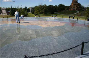
 The map of the five Nordic countries: Denmark, Finland, Iceland, Norway, and Sweden, was completed in summer 2011.
This beautiful work of art is 75 feet in diameter and executed in different colored granite tiles with a background of Norwegian Blue Pearl Granite. The shimmering blue-black granite, (representing the ocean of Scandinavia), creates a dramatic vision and a most unique structure for the park.
The map plaza with its position at the entrance to the park is a reception and disembarkation area for visitors. This actual map representation of the Scandinavian countries also serves as an educational tool for visitors to the park. Integrated into the map plaza is a bronze compass and eight strategically positioned observation/rest benches of granite.
Granite was selected for this project for its long-term durability and is second only to diamonds in its hardness.
The bronze compass inset into the granite also serves as the name-place for this monumental map of Scandinavia. The names of the countries and their capital cities are also on bronze plaques which are inset on the map at the capitals’ locations.
Along with the other structures in the park, it serves to commemorate and honor the Scandinavian immigrants, who left their homes across the ocean and endured many hardships to establish their new homes in North America. Their contributions to life in the New World have been very many.
